|
Forums46
Topics538,498
Posts9,737,776
Members87,094
| |
Most Online25,604
Feb 12th, 2024
|
|
|
 Ranch Mapping software
#2988990
02/05/12 07:58 PM Ranch Mapping software
#2988990
02/05/12 07:58 PM
|
Joined: Feb 2009
Posts: 74
BaylorChase
 OP
OP
Outdoorsman
|
|
OP
Outdoorsman
Joined: Feb 2009
Posts: 74 |
I am trying to map out the locations by gps of all of the blinds on the family ranch. Anybody familiar with any software that would be able to indicate where the blinds, houses, gates, etc. are located and overlay the locations on a satellite image of the property? Also what gps would be good for marking these locations and connecting to the computer? Is it possible to do this with google earth?
|
|
|
 Re: Ranch Mapping software
[Re: BaylorChase]
#2989130
02/05/12 09:05 PM Re: Ranch Mapping software
[Re: BaylorChase]
#2989130
02/05/12 09:05 PM
|
Joined: Jan 2012
Posts: 2,014
DesertHunting
Veteran Tracker
|
|
Veteran Tracker
Joined: Jan 2012
Posts: 2,014 |
I did ours using Google Earth. You can draw lines in to mark the fences and get long/lat that will get you real close to the acual position. I pin pointed stands and water troughs using different marking icons. Once you've marked everything you can save image and print it out.
|
|
|
|
Re: Ranch Mapping software
[Re: DesertHunting]
#2989155
02/05/12 09:18 PM
|
Joined: Aug 2005
Posts: 32,024
txtrophy85

THF Celebrity
|
|
THF Celebrity
Joined: Aug 2005
Posts: 32,024 |
use google earth.
very easy
For it is not the quarry that we truly seek, but the adventure.
|
|
|
|
Re: Ranch Mapping software
[Re: txtrophy85]
#2989158
02/05/12 09:18 PM
|
Joined: Aug 2005
Posts: 32,024
txtrophy85
THF Celebrity
|
|
THF Celebrity
Joined: Aug 2005
Posts: 32,024 |
using google earth, you should be able to come up with something like this 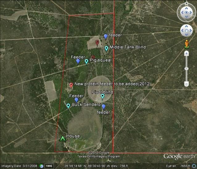
For it is not the quarry that we truly seek, but the adventure.
|
|
|
|
Re: Ranch Mapping software
[Re: txtrophy85]
#2990285
02/06/12 05:09 AM
|
Joined: Nov 2011
Posts: 1,269
GriffGruff78
Pro Tracker
|
|
Pro Tracker
Joined: Nov 2011
Posts: 1,269 |
There's an iPhone app called "Field Notes". If you drive around the property you can mark game trail crossings, fence corners, feeders, blinds, etc. etc. and export all of them to Google Earth in .kmz format. You can also snap pictures that will pop-up in the information tab when viewed through Google Earth. Pretty cool stuff.
Of course, you can also just drop pins in Maps from your iPhone to get lat/longs that can be manually entered into Google Earth.
|
|
|
|
Re: Ranch Mapping software
[Re: GriffGruff78]
#2990326
02/06/12 05:48 AM
|
Joined: Aug 2007
Posts: 1,464
HardWired
Pro Tracker
|
|
Pro Tracker
Joined: Aug 2007
Posts: 1,464 |
^^^^ that sounds pretty good!
I have used Delorme maps, and have GPS built into the computer. It works the same as above, but possibly not as clean of an interface.
|
|
|
|
Re: Ranch Mapping software
[Re: HardWired]
#2990909
02/06/12 04:04 PM
|
Joined: Sep 2009
Posts: 3,453
dfwroadkill
Veteran Tracker
|
|
Veteran Tracker
Joined: Sep 2009
Posts: 3,453 |
Google Earth worked great for me... 
|
|
|
|
Re: Ranch Mapping software
[Re: dfwroadkill]
#2996162
02/08/12 03:52 AM
|
Joined: Feb 2012
Posts: 1
Island Ranch
Green Horn
|
|
Green Horn
Joined: Feb 2012
Posts: 1 |
Check out www.depiction.com. I use this for all my mapping. It isn't free costs $199 but it gives you a lot more flexibility than google earth. Once you create your map it stores everything on your local hard drive so you don't need to be hooked up to the internet to use it. You can also simulate floods and other events. It can read gpx,shp,gml, kmz, and csv files. You can also place icons based on at lat/long or you can just place them with a mouse. Has a lot of built in icons or you can use your own. They also have a cheaper version called depicitonprep. www.depictionprep.com it only costs $29.95 but doesn't have all of the bells and whistles.
|
|
|
|
Re: Ranch Mapping software
[Re: DesertHunting]
#2996406
02/08/12 06:03 AM
|
Joined: Nov 2011
Posts: 123
NockedUp
Woodsman
|
|
Woodsman
Joined: Nov 2011
Posts: 123 |
I did ours using Google Earth. You can draw lines in to mark the fences and get long/lat that will get you real close to the acual position. I pin pointed stands and water troughs using different marking icons. Once you've marked everything you can save image and print it out. x2 - and its free and they update the photos fairly ofter. Also,Garmin makes some very user friendly GPS units
|
|
|
|
Re: Ranch Mapping software
[Re: NockedUp]
#2997483
02/08/12 06:57 PM
|
Joined: Jun 2011
Posts: 73
jashle
Outdoorsman
|
|
Outdoorsman
Joined: Jun 2011
Posts: 73 |
I wouldnt say "often"....the google image of my ranch has to be at least 4-5 years old. I had to get an areal photo done this past season to get an accurate picture. They might update photos from less remote places more often but ours is out in the boonies so we were SOL.
|
|
|
|
Re: Ranch Mapping software
[Re: jashle]
#2998038
02/08/12 10:04 PM
|
Joined: Nov 2011
Posts: 191
Kingpin
Woodsman
|
|
Woodsman
Joined: Nov 2011
Posts: 191 |
Check out Garmin. You can use their software to create a .kmz file and upload to Google Earth.
|
|
|
|
Re: Ranch Mapping software
[Re: Kingpin]
#2998527
02/09/12 12:52 AM
|
Joined: Nov 2011
Posts: 3,085
Don Dial
Veteran Tracker
|
|
Veteran Tracker
Joined: Nov 2011
Posts: 3,085 |
Why, every County in Texas usually has an aerial survey of the propertys...DD
|
|
|
Moderated by bigbob_ftw, CCBIRDDOGMAN, Chickenman, Derek, DeRico, Duck_Hunter, hetman, jeh7mmmag, JustWingem, kmon11, kry226, kwrhuntinglab, Payne, pertnear, rifleman, sig226fan (Rguns.com), Superduty, TreeBass, txcornhusker
|